Guatemala Evacuates 250 as Fuego Volcano Spews Lava
Central America's most active volcano woke up, and history says why officials moved fast.

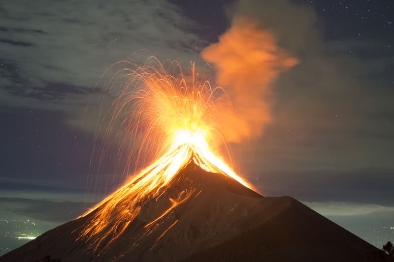
Fuego does not send a warning card. On Monday morning the volcano started pushing gas and ash into the sky over southern Guatemala, and by evening the eruption had grown loud enough that officials told two villages to grab what they could and leave. Central America's most active volcano was firing a fountain of lava hundreds of feet above its crater, while an ash plume climbed roughly four miles into the air.
The country's disaster agency, CONRED, laid out the timeline to reporters. The eruption started early and kept building all day, and the escalation is what pushed officials to act. Live images showed thick clouds rolling over the mountain as lava and pyroclastic flows raced down the slopes. If you have never seen a pyroclastic flow move, imagine an avalanche of superheated rock, gas, and ash traveling faster than anything you would want to outrun on foot.
Two Villages Told to Get Out
The evacuation order hit two small communities on the mountain's flanks: El Porvenir and the hamlet of Las Lajitas. That works out to around 50 families, or about 250 people, moved as a precaution. CONRED called it preventive, which is the whole point. You do not wait for the lava to reach the front door before you leave.
Families from the area were bused to a temporary shelter in San Juan Alotenango, a town at the base of the volcano. According to reports out of Guatemala, the families arrived Tuesday and settled into shelter housing while crews kept watch on the crater. The lava fountain reached between 200 and 300 meters over the top, which is somewhere between 650 and 1,000 feet, per the national volcanology and weather institute known as INSIVUMEH.
What an Orange Alert Actually Means
Guatemala declared a nationwide orange alert, which is the second-highest level in the country's warning system. Orange means real danger, not a heads-up. The agency warned that ash could drift well beyond the two evacuated villages and settle over other nearby towns, so the impact stretches further than the couple hundred people who packed their bags.
Officials also told residents in the surrounding zone to prepare go-bags and emergency supplies, and to stay out of ravines. That last instruction matters more than it sounds. Ravines and drainage channels are exactly where fast-moving flows travel, and standing near one during an eruption is how people end up in the wrong place. The danger alert signaled that the risk was being treated as a national concern, not just a local one.
Closed Roads and Canceled School
The ripple effects showed up fast in the surrounding region. Authorities shut down National Route 14, a major highway that runs close to the volcano and connects towns on Fuego's slopes to Antigua, the old colonial city that draws tourists from all over. Antigua is a UNESCO World Heritage site, so closing the road that feeds into it is a big deal for anyone trying to move through that part of the country.
The Education Ministry also suspended classes in the nearby towns. Between the shuttered highway and the closed schools, the eruption reached far past the two evacuated hamlets. Fuego sits only about 35 kilometers from Guatemala City, so this is not some remote mountain in the middle of nowhere. The capital is close enough that the whole country pays attention when the volcano wakes up.
Why Everyone Remembers 2018
The reason officials move quickly on Fuego comes down to one date: June 3, 2018. That day the volcano produced a sudden, violent eruption that sent a pyroclastic flow racing down the Las Lajas drainage on the southeast side. The flow jumped its banks and buried the community of San Miguel Los Lotes along with parts of El Rodeo.
The official count put the confirmed dead at around 200, with hundreds more reported missing. Many bodies were never recovered because the deposits stayed too hot to dig through for days and sat too deep to fully clear afterward. According to accounts from people living in the region, it was the deadliest single volcanic event in Guatemala since Santa María erupted back in 1902. The broader disaster affected as many as 1.7 million people across the area, once you count everyone touched by the ashfall, displacement, and closures.
After 2018, monitoring got a serious upgrade. INSIVUMEH added seismic stations and gas-monitoring gear so the mountain gets watched around the clock. Government alerts now push straight to Guatemalan cell phones by text, mostly in Spanish, and CONRED posts real-time bulletins on its social channels. That system is a direct answer to the lesson of 2018, when the flow arrived faster than many people could react.
This Is Not a Rare Event for Fuego
Here is a fact that surprises a lot of people. Fuego's current eruptive episode started back in 2002 and has technically never stopped. That makes it the longest stretch of activity in the volcano's recorded history. The mountain does not fully go quiet; it just cycles between low rumbling and the sudden, intense bursts that scientists call paroxysmal events. Those bursts hit multiple times a year and are the ones that threaten the towns below.
The track record is genuinely wild. Since 1524, Fuego has logged at least 55 documented eruptions. Since 1900 alone it has erupted 46 times and been active during 46 of those 127 years. Zoom out to the past 10,000 years and the count climbs to at least 61 confirmed eruptions. Do the math on the historical record and the volcano has been erupting during roughly one out of every six years. Detailed volcano records describe Fuego as a basaltic stratovolcano built by the Cocos Plate grinding underneath the Caribbean Plate, which is a mouthful that basically means this mountain has been in the business of erupting for a very long time.
Guatemala sits on the Pacific Ring of Fire, the horseshoe-shaped belt where a huge share of the world's earthquakes and eruptions happen. Living near Fuego means accepting that the mountain is part of the deal. Communities cluster around its base because the volcanic soil is good for farming, which is the tradeoff people have made for generations.
Evacuations Are Becoming a Regular Drill
Because Fuego stays busy, mass evacuations have turned into an almost routine response in recent years. The year before this eruption, authorities moved more than 500 people out of communities near the crater after Fuego threw gas and ash. Back in 2023, another eruption forced the evacuation of around 1,200 people. Each time, the playbook looks similar: raise the alert, empty the closest villages, close the roads, and wait for the crater to settle down.
That repetition can make the warnings feel routine, but the 2018 disaster is the reason nobody in charge treats them casually. When you have watched a flow bury an entire village in minutes, a preventive evacuation of 250 people looks like a bargain. The danger alert issued this week fits that cautious pattern, with the road to Antigua closing to keep traffic away from the flanks.
What Happens From Here
For now, the families from El Porvenir and Las Lajitas are in the shelter at San Juan Alotenango while monitoring teams track the crater. INSIVUMEH stations and CONRED bulletins updated through the day as the activity escalated, and the Washington-based ash advisory center tracks the plume's altitude and drift to warn aircraft flying through the region. Ash in the air is a headache for planes, so the plume matters far beyond the ground below.
Hiking Fuego itself is not something anyone does anymore. Approaches to the upper cone are restricted and reserved for monitoring and research crews who coordinate with INSIVUMEH. Anyone traveling in the Antigua area is better off checking the official bulletins than trusting a single dramatic photo, since the trend over several days tells you far more than one big burst on one afternoon. According to emergency officials, the guidance stays the same: keep a go-bag ready, avoid the ravines, and listen for the text alerts. Fuego has done this dozens of times before, and it will almost certainly do it again.
Most read
This week

Entertainment
Michael Douglas Says He Hid Kathleen Turner Affair for 40 Years

Crime
Nathalie Belizaire Charged After 4 Children Found Alone During Cruise
Crime
Two Oxford Vape Clerks Charged in Ole Miss Kratom Investigation

Crime
Sinema's Ex-Bodyguard Arrested Again Over Knife at Phoenix Gun Shop

Entertainment
Judge Grants Restraining Order Against Halle Berry Over Choking Claim