Massive Tornado Outbreak Rips Across the Central US This Week
One Nebraska family's dream home was gone in 11 minutes.

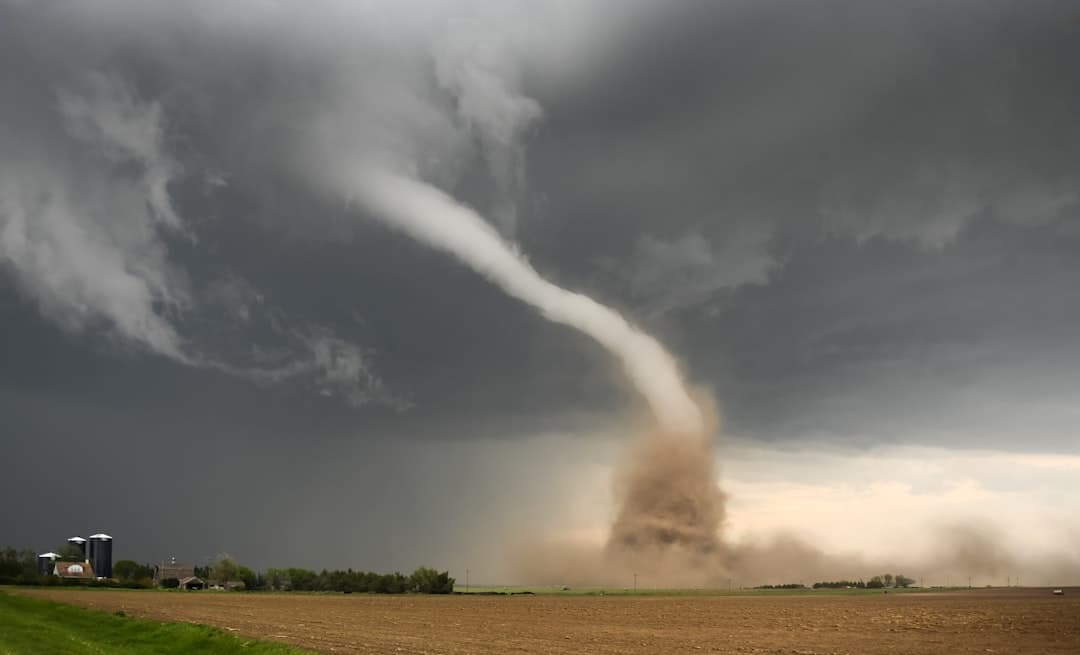
Starting Saturday, May 16, 2026, a multi-day severe thunderstorm system tore across the central United States, spawning dozens of tornadoes, flattening homes, and putting tens of millions of people on edge. The outbreak stretched from Kansas to Michigan, with the worst destruction concentrated in Nebraska, where an EF-3 tornado obliterated homes in a small community north of Grand Island. By the time the system began to weaken on Tuesday, it had also triggered hurricane-force wind gusts, wildfires, and flash flooding across multiple states.
Here's everything we know about what happened, where it happened, and what the damage looks like on the ground.
St. Libory, Nebraska, Takes the Hardest Hit
The most destructive tornado of the entire outbreak struck near St. Libory, Nebraska, on Sunday evening, May 17. The tornado touched down at 5:04 PM CDT and was on the ground for 11 minutes, reaching peak wind speeds of 160 mph. The National Weather Service in Hastings gave it a preliminary rating of a high-end EF-3.
The twister strengthened as it crossed U.S. Highway 281 and plowed directly into the Denton Circle housing development, a rural subdivision along the northern edge of St. Libory. Four homes in the development were destroyed, along with two detached garages. Irrigation pivots in nearby fields were overturned. Power lines were snapped. A mangled vehicle was found in front of one of the destroyed homes, and tractors in surrounding fields were flipped upside down.
Remarkably, nobody was killed. Two people and a dog had to be rescued from the basement of a collapsed home by emergency personnel, but Howard County Emergency Management confirmed zero injuries.
"Like a Freight Train": Families Describe the Moment
Bo Bruning and his wife Michaela lived in one of the destroyed homes in Denton Circle. They described the house as their dream home. It's gone now.
Bo said the tornado sounded "like a freight train." Michaela sheltered with their four-month-old baby, holding the infant "like a football," while their two-and-a-half-year-old was pushed into the corner of a storage space beneath their stairs. They survived. Their home did not.
Another St. Libory resident, Christina Parden, initially mistook the approaching tornado for a rain wall. Then she saw whole trees and power lines floating through the air. "I've just never been so scared," she said.
By Monday morning, community members, friends, and family returned to the wreckage to begin sifting through rubble. Photos showed children's bedrooms completely exposed where rooftops had been ripped away. Among the personal belongings recovered from the debris was a Nebraska Huskers flag. The St. Libory Volunteer Fire Department asked people to stay away from the area while downed power lines and scattered debris made conditions dangerous. Personnel from the American Red Cross were also on site assisting residents.
Sunday's Tornado Count Stretched Across Multiple States
The St. Libory EF-3 was the most powerful tornado on Sunday, but it wasn't the only one. Two tornadoes touched down in Howard County alone. The first started just before 5:00 PM near the town of Dannebrog, roughly five miles to the southwest. The second was the St. Libory twister minutes later.
A separate tornado struck near Hebron, Nebraska, in Thayer County, about 65 miles southwest of Lincoln. That one was classified as an EF-1 with winds between 86 and 110 mph. The National Weather Service issued a rare tornado emergency for Hebron as the twister rapidly developed right outside the town.
Tornado damage was also reported north of Ashland, Nebraska, and homes near Plattsmouth, south of Omaha along the Missouri River, were struck. Reports of tornado activity extended into northwest Iowa and southern Minnesota, with storms observed near Mason City and Worthington. Wind gusts up to 82 mph were recorded near Estherville, Iowa, where a grain elevator took damage.
Monday Brought an Even Bigger Threat
If Sunday was bad, Monday was worse in terms of sheer scale. NOAA's Storm Prediction Center issued a rare Level 4 out of 5 risk for severe thunderstorms covering parts of Kansas and southeastern Nebraska. A broader severe weather threat covered more than 80 million people across a corridor stretching over 1,000 miles from North Texas to western New York.
The SPC also issued a Particularly Dangerous Situation (PDS) tornado watch for parts of northeastern Kansas and southeastern Nebraska. That designation is rare and reserved for situations where forecasters are especially concerned about intense, long-track tornadoes. The watch area faced threats of multiple tornadoes at EF-2 intensity or greater, along with winds up to 70 mph and hail the size of apples.
Cities including Wichita, Topeka, Omaha, Kansas City, and Des Moines were all inside the risk zone.
Monday delivered. Confirmed tornadoes were reported in Gage and Jefferson counties in Nebraska. A tornado emergency was issued for Pawnee City. Multiple tornadoes ripped across northeastern Kansas, southeastern Nebraska, and southern Iowa. A classic stovepipe-shaped tornado cut through farmland in Richardson County, Nebraska, causing limited damage and no injuries. A tornado also caused damage in Blue Rapids, Kansas.
Hurricane-Force Winds, Wildfires, and Flash Floods
Tornadoes got the headlines, but the broader storm system brought destruction in other forms too.
Monday's storms charged across the Great Lakes with straight-line winds that hit hurricane force. A 79 mph gust was clocked at Chicago's Midway Airport. Near Grand Rapids, Michigan, winds reached 81 mph. Damaging wind gusts of 92 mph impacted areas west of Kansas City, Missouri. The National Weather Service issued a Severe Thunderstorm Warning with a "destructive" tag for wind gusts exceeding 80 mph.
Meanwhile, high winds from the same system fueled rapid wildfire growth across the southern High Plains. Over 100,000 acres burned in southwest Kansas. The Meade County Complex 1 fire alone exceeded 92,000 acres and sat at 0% contained as of Monday. Evacuations were ordered for the towns of Meade and Fowler, Kansas, though they were later lifted.
Flash floods struck Iowa, Kansas, Nebraska, and Indiana. Water rescues were reported in Martinsburg and New Pekin in Washington County, Indiana. Flash Flood Warnings were issued for parts of Illinois and Missouri as the system continued to dump heavy rain.
Ten Tornadoes Confirmed So Far, With More Surveys Coming
As of the latest reports, ten tornadoes were confirmed from the May 17-18 outbreak period. The National Weather Service announced it would conduct additional damage surveys over the coming days to determine the full count, intensity, and ground tracks of all tornadoes from the event.
The strongest confirmed tornado remains the St. Libory EF-3 at 160 mph. No fatalities were reported from this outbreak, which is remarkable given the power of the storms involved.
NOAA's National Severe Storms Laboratory had researchers staged and ready to gather data from Monday's storms. The LIFT campaign, a research initiative, was positioned in central Kansas with high-speed camera systems designed to capture data on tornadoes and hail.
An Unusually Quiet Start to May Made This Outbreak a Shock
What made this outbreak feel so jarring was the timing. May is historically the most active tornado month in the United States, but the first two weeks of May 2026 had been unusually quiet. Forecasters noted this outbreak marked a significant shift from that earlier calm pattern, driven by a change in the large-scale weather regime.
Earlier in the season, long-range forecasters had predicted 1,050 to 1,250 tornadoes for 2026, compared to 1,544 preliminary reports in 2025. The forecast called for a front-loaded pattern with more severe weather in March and early April. That prediction held up through mid-April, but May's quietness lulled a lot of people into thinking the worst had passed.
Then this happened.
By Tuesday, the Threat Began to Ease
By Tuesday, May 20, the storm system was pushing south and east. The severe thunderstorm risk dropped to a Level 2 out of 5, stretching from Texas to the eastern Great Lakes and northern New England. Damaging winds and hail remained the primary concerns Tuesday afternoon and evening, with the Lower Ohio Valley and parts of central and eastern Texas facing the most risk.
The tornado threat wasn't completely gone, but it had diminished considerably from the Level 4 danger that defined Monday.
What This Outbreak Looked Like by the Numbers
Here's a quick rundown of the key figures from the May 17-19 outbreak:
The strongest tornado was the St. Libory EF-3 at 160 mph. Ten tornadoes were confirmed across the outbreak period. More than 80 million people were under some level of severe weather threat on Monday alone. Hurricane-force winds reached 92 mph west of Kansas City. Over 100,000 acres burned in Kansas wildfires fueled by the same system. Four homes were destroyed in the Denton Circle development. Zero fatalities were reported from the tornadoes.
The fact that nobody died in this outbreak is nothing short of extraordinary, given what the storms produced. But the images coming out of St. Libory, with roofless homes, upended tractors, and families picking through rubble, tell a story that statistics alone can't capture. For the Brunings and their neighbors, this was everything they had. And an 11-minute tornado took it.
Most read
This week

Crime
Christa Pike Awake and Speaking After Tennessee Execution Fails

Politics
Seven Senate-Confirmed Treasury Officials Exit Amid Bessent Outbursts

Entertainment
Jim Bakker, Televangelist Who Went to Prison for Fraud, Dies at 86

Crime
Marine Devin Ballard Arrested in Okinawa Hotel Killing of Anna Yagi

Politics
Dennis Hastert, House Speaker Who Went to Prison, Dies at 84